May 5th was 350.org's "Connecting the Dots" day, and students in Environmental Science collected their thoughts and reflections on the impact of Hurricane Irene in Southern Vermont. The idea behind the day of action is that climate change, when viewed through a localized scope, can sometimes just feel like the weather in a region is a little "off"... but when we connect the dots from around the world, these erratic events demonstrate predictable patterns that support some serious climate issues. Read more at www.350.org
Our dot compiled images from volunteer efforts in Wilmington and Jamaica, VT, as well as personal reflections. A poignant comment: "I watched my childhood home get destroyed."
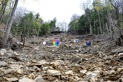
On Saturday, Jim and Marilyn organized a hike out to Lye Brook Falls in Manchester, VT. The hike used to be notable for culminating in one of the longest waterfalls in the state (approx. 125, though not free-falling.) Post-Irene, though, the most impressive characteristic is the enormous landslide that opened up during the storm.
To give a sense of scale: there are two men sitting on the horizontal log in the middle of this photo...
Looking down from about the midway point.
Thomas, with his climate dot, looking upslope
Putting our dots together. Photo credit for this shot goes to Hubert Schriebel


No comments:
Post a Comment